Our Cairns Coast
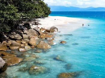
Our unique coastal environment is an important community and economic asset and is highly valued by our 164,000 residents and 2.9 million annual visitors alike. But our coastline is dynamic and always changing.
Council has been working with the Queensland Government through the QCoast2100 program to plan for and respond to current and future coastal changes from erosion, storm tide inundation and sea level rise from now until the year 2100.
The development of “Our Cairns Coast: Adapting for the Future has helped us understand what long-term coastal changes mean for our community, our businesses and our infrastructure, and to plan for resilience.
Our Cairns Coast is a strategy that will guide our mitigation and adaptation actions to the year 2100.
Read the Coastal Hazards Adaptation strategy
On 13 July 2022, Council endorsed the Coastal Hazard Adaptation Strategy for the Cairns Regional Council Local Government area, which is a guide tp decision-making, planning and responses in managing natural threats to our coast from erosion, storm-tide inundation and sea level rise to the year 2100.
Within the Strategy, we mapped the potential areas affected by coastal hazards to the year 2100 in 14 key locations, based on the State Government’s mandated 0.8m sea level rise, and outline proposed actions to address these hazards.
Our Cairns Coast Strategy ( PDF, 10.27 MB )
About the project
Cairns is one of 31 coastal councils that has or is developing a Coastal Hazard Adaptation Strategy through the QCoast2100 program.
A consultant team with technical expertise was engaged to assist Council in the project, which was also supported by subject matter experts from inside and outside Council and community contributors.
The eight-phase multi-year CHAS process aimed to:
- better understand the coastal changes (hazards) we can expect to see, what areas are at risk and what this means for our community, our businesses and our infrastructure;
- plan for resilience by identifying what actions we need to take – and when – to avoid or reduce these impacts;
- take a coordinated approach to coastal planning and adaptation across the region.
Coastal hazards - coastal erosion, storm tide inundation (cyclonic and non-cyclonic) and sea level rise - can affect the things we value about Cairns: its natural beauty, tropical lifestyle, sense of community and the many ways we use and enjoy the coast, and impact on our community’s infrastructure – our roads, services, and properties.
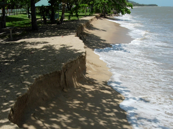
Coastal erosion
Loss of land or removal of beach or dunes by waves, wind, currents, water flows or permanent inundation due to sea level rise.
Sea level rise
An increase in sea level caused by global warming due to climate change, leading to the periodic or permanent loss of land to the sea.
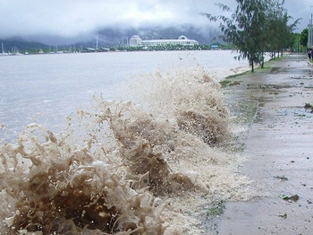
Storm tide inundation
Temporary inundation of land by abnormally high ocean levels caused by cyclones and severe storms.
Adapting to coastal changes and hazards
Our options to mitigate and adapt to these changes include:
- avoid placing assets in vulnerable areas
- protect and enhance our natural coastal ecosystems
- accommodate and modify at-risk assets on our coast
- transition assets in areas of intolerable risk
- defend assets using hard structures like sea walls.
Different options will be appropriate in different locations.
Cairns Regional Council has been addressing the ongoing issue of erosion/loss of sand on the northern beaches for many years, with a particular focus on the highly impacted Holloways Beach and Clifton Beach. The erosion poses a risk to the amenity of our beaches, to the vegetation that lines them and to nearby properties and infrastructure.
What has Council done so far?
- Continued to add sand at Holloways Beach and Clifton Beach. Unfortunately, this is not a sustainable solution due to the high cost and unpredictability of how long the sand will stay in place.
- Developed a new Shoreline Erosion Management Plan with options to mitigate erosion, including construction of two groynes at Holloways Beach in 2021 that have proven effective.
- Undertook a Sand Sourcing Study to see how much sand is available and where it can be secured for the purpose of beach nourishment.
What is Council’s future solution?
Council now intends to install rock headlands at Holloways Beach and Clifton Beach. These are physical structures placed near the shore, running parallel to the beach, which:
- Mimic naturally occurring rock formation to encourage sand retention.
- Have proven successful in other parts of Queensland and overseas.
- Reduce the frequency and cost of sand nourishment.
- Retain the beach’s amenity for users.
What happens next?
Council has obtained the necessary approvals to install three breakwaters at both Holloways Beach and Clifton Beach.
The installations at Holloways Beach are almost complete and those at Clifton Beach have commenced with completion expected by October 2025.
The breakwaters won’t stop sand erosion completely and Council will still need to add sand in the future, however the frequency of nourishment will be significantly reduced.
Council will continue to address erosion at other beaches through normal initiatives such as sand nourishment.
You can find out more about the Holloways Beach breakwaters here and about the Clifton Beach breakwaters here.
Technical studies and mapping
Council updated its coastal hazard mapping assisted by funding from the QCoast2100 program. This refined mapping identifies areas along the Cairns coast that are likely to be affected by current and future coastal hazards being coastal erosion, storm tide inundation and sea level rise from climate change.
The updated Erosion Hazard Area mapping indicatively shows the landward extent of the coast that is potentially vulnerable to coastal erosion (short term and/or longer term coastal processes) and assumes no adaptation action is undertaken. This mapping is for the purpose of obtaining feedback and is updated from the current State Erosion Prone Area at the year 2100. In some cases, this mapping aligns with or is less than the area identified on the current State mapping and does not encroach as far landward.
The areas indicated on the map are indicative only and do not represent a shoreline position or where land may be lost to coastal processes. The mapping incorporates erosion controls such as bedrock and engineered seawalls. The mapping does not consider any other features that may limit the extent of erosion such as roads or buildings.
The Storm Tide Inundation mapping identifies those areas of the coast potentially affected by temporary inundation from the sea during a tropical cyclone (or other severe weather event) and assumes no adaptation action is undertaken. The mapping does not include riverine or waterway flooding caused by rainfall.
The 1% AEP* storm tide has been mapped for five planning horizons: 2020, 2040, 2060, 2080 and 2100 and identifies water depths and inundation extents. The mapping includes an allowance for wave processes that occur near the coastline.
Mapping is indicative only and has a statistical basis. It does not represent the storm tide inundation associated with a single tropical cyclone or severe weather event.
*Annual Exceedance Probability (AEP) is the likelihood or probability of a threshold being exceeded in any given year. For the 1% AEP storm tide, this means ‘on average’ there is a 1% chance of the coastal water level and associated inundation of this size or larger, occurring in any one year.
The sea level rise mapping indicates areas that will potentially form part of the intertidal zone and assumes no adaptation action is undertaken.
Consistent with the State’s requirements, the updated mapping includes an allowance of 0.8m sea level rise by the year 2100, due to the impact of climate change. Mapping has been prepared for each planning horizon and is based on present day Highest Astronomical Tide (HAT) plus a sea level rise allowance for each planning horizon out to the year 2100. Mapping is indicative only and does not represent a shoreline position or where land may be lost to coastal processes.
* Disclaimer: The coastal hazard mapping above is in draft form and is for the purpose of engagement and preparation of the strategy for the Our Cairns Coast project. This draft mapping does not replace the planning scheme maps published in PDF format on Council’s website. Where inconsistencies are found between the interactive mapping and the PDF maps, the PDF maps prevail to the extent of any inconsistency. In some cases, State mapping will prevail over the CairnsPlan 2016 mapping.
This information is subject to change and should not be relied on to make decisions, particularly in regard to property transactions, to value property, for insurance purposes, or to make any decisions which may have financial or legal implications.
If you wish to obtain definitive information with respect to any property, you should request appropriate searches of Council information in accordance with standard procedures by contacting Council.
While all reasonable care has been taken in producing the information, Council does not warrant the accuracy, completeness or currency of this information and accepts no responsibilities for, or in connection with, any expense, loss, damage or liability (including indirect or consequential loss) arising as a result of any inaccuracies, errors or omissions, or your reliance on or use of this information.
The copyright of the information available through this website is owned by or licensed to Cairns Regional Council. Council reserves all intellectual property rights in the information and does not confer any intellectual property rights on you or any other person by making the information available.
The Queensland Government has made publicly available State-wide coastal hazard mapping for the purpose of development assessment and to inform planning scheme preparation. Links to the State Mapping and further information on the technical methodologies can be found below.
Further reading
- Australian Government Bureau of Meteorology and CSIRO State of the Climate 2020 report
- Queensland Government Coastal hazard technical guide
- Queensland Government Far North Queensland Climate Change Impact Summary
- Climate Change in Australia website - www.climatechangeinaustralia.gov.au
Last Updated: 9 July 2025
Latest News > All News

New Ferris wheel for Cairns Esplanade
A new Ferris wheel is coming to Cairns, with works now underway to replace the existing Reef Eye attraction on...
13 July 2026
Temporary closure of Babinda Transfer Station
The Babinda Transfer Station will be closed on Wednesday 15 July to allow for the processing of green waste on...
13 July 2026

Traffic changes for Cairns Show
Residents are advised there will be changed traffic conditions associated with the Cairns Show....
10 July 2026