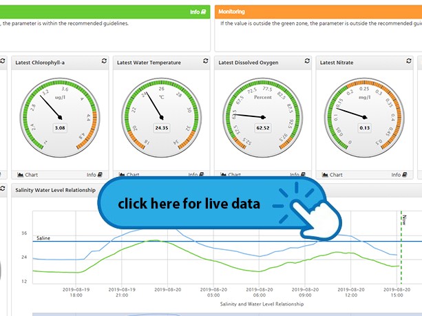
Live data – Saltwater Creek
Live data from Saltwater Creek gauging station.
What we're monitoring | Its part in a healthy waterway | What is healthy? | ||
|---|---|---|---|---|
Dissolved inorganic nitrogen (DIN) levels - Load and concentration | Nitrogen is a gas that makes up almost 80% of the earth’s atmosphere. Nitrogen is essential to all life on earth but too much can be harmful. Load is a measurement of concentration x flow. Flow is a measurement of volume of water flowing in the river per unit of time (e.g. litres flowing per second or m3 per second). |
*As per the Barron River Basin Environmental Values and Water Quality Objectives for protection of aquatic ecosystems. | ||
Water Clarity (Turbidity) | Turbidity is a measure of how particles suspended in water affect water clarity. The effects of these suspended solids on fish and aquatic life are an extremely important cause of water quality deterioration. Increased turbidity will also increase water temperature, lower dissolved oxygen and prevent light from reaching aquatic plants. |
| ||
Temperature | Water temperature is affected by air temperature, stormwater runoff, groundwater inflow, turbidity and exposure to sunlight. The maximum temperature is the highest water temperature the organism can live for a few hours. The optimum (normal) temperature is the temperature at which it will thrive. Water temperatures outside the “normal” range for a river or creek can cause harm to the aquatic organisms that live there and add to rising ocean temperatures that can lead to coral bleaching. |
| ||
Dissolved Oxygen | Aquatic plants and animals rely on oxygen that is dissolved in the water for survival. This 'Dissolved Oxygen' is the most important indicator of the health of a body of water. Levels of dissolved oxygen vary depending on factors including water temperature, time of day, season, depth, altitude, and rate of flow. Consistently high levels of dissolved oxygen are best for a healthy ecosystem and when it drops too low can be devastating for the environment. A major cause of low dissolved oxygen is the decomposition of organic material (palm fronds, grass cuttings, leaves etc), as the organic material breaks down oxygen in the water is consumed. If the dissolved oxygen levels drop too low, there is not enough for animal survival and it can lead to ‘fish kill events’, where large numbers of fish die within a short period. |
| ||
pH | pH is a scale in chemistry used to measure the acidity or alkalinity of a solution. If the pH level of water is too high or too low, the aquatic organisms living in it will die. Changing levels of pH in a creek or river can be an indicator of increasing pollution or some other environmental factor. |
| ||
Chlorophyll - a | Chlorophyll-a is a green pigment found in plants. It absorbs sunlight and converts it to sugar during photosynthesis. Monitoring Chlorophyll-a is a commonly used measure of water quality and concentrations are an indicator of algae abundance and productivity in aquatic environments. Higher concentrations typically indicate poor water quality, usually when high algal production is maintained due to high nutrient concentrations. It is natural for chlorophyll-a concentrations to fluctuate over time and they are often highest after rain, particularly if the rain has flushed nutrients into the water during the warmer, sunnier months of the year. |
| ||
Salinity | Salinity is a measure of the content of salts in soil or water (mainly sodium chloride (common table salt)).The water in rivers and creeks is usually fresh, oceans are salty. Excessive amounts of dissolved salt in freshwater can affect ecosystem health, including native vegetation, to die. Salinity can occur with land clearing and altered land use. Saltwater Creek is tidal and has both freshwater and saltwater areas. |
| ||
Depth and flow | The overall size, depth and flow of a waterway can affect its water quality. For example contaminants entering deep and fast moving rivers will have less effect on the river than the same amount of contaminants entering a slow moving, shallow creek. However tides, weather, the landscape and obstructions such as rocks, fallen trees and bends in the waterway, will further influence depth and flow. Measuring flow allows us to observe any change in the load of contaminants and sediment that may be in the water. Load is a measurement of concentration x flow. How deep a creek is can also affect other ‘parameters’ of water quality, such as temperature and light which both decrease with depth. Depth will also affect how stormwater is discharged from the catchment. |
|
Last Updated: 3 March 2022
Latest News > All News
King tides are expected to impact Cairns this week
Residents are advised that king tides will be experienced in Cairns from Thursday 2 May through to Friday 10 May...

CEO finishes at Cairns Regional Council
Chief Executive Officer Mica Martin has resigned from her role at Cairns Regional Council....

Australia’s best loved scientist coming to Ecofiesta
The country’s best known and most charismatic scientist is coming to town as a special guest of Cairns Ecofiesta 2024....